3D Data Capture
From Point Clouds to Predictive Asset Management
What is 3D Data Capture?
Digital scanning solutions transform physical assets into intelligent models, driving data-based decisions that reduce rework, enhance quality control, and support digital twins - revolutionizing how projects are designed, built, and maintained for maximum efficiency

Terrestrial laser scanning
Welcome visitors to your site with a short, engaging introduction. Double click to edit and add your own text.
Aerial Laser Scanning
Aerial Laser Scanning
DPS uses advanced aerial LiDAR (Light Detection and Ranging) technology to capture high-resolution 3D data from the air. By mounting laser scanning systems on drones or aircraft, we can efficiently map large or inaccessible areas with exceptional accuracy.
How We Use It for 3D Laser Scanning
-
Data Capture at Scale – We collect millions of precise elevation points in a single flight, creating detailed digital terrain and surface models.
-
Integration with Digital Twins – Captured LiDAR data is processed into accurate 3D models, seamlessly integrated with our digital engineering workflows.
-
Remote & Hard-to-Reach Access – Perfect for surveying industrial plants, infrastructure, or terrain where ground-based scanning is impractical.
Benefits for Your Project
-
Speed & Efficiency – Reduce survey time from weeks to days.
-
High Accuracy – Achieve centimetre-level precision over wide areas.
-
Cost-Effective – Minimise labour, access challenges, and on-site disruptions.
-
Comprehensive Coverage – Capture both the visible and hidden features of a site.

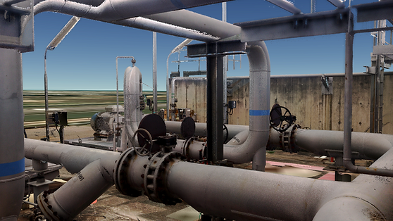
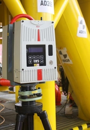
Terrestrial Laser Scanning
DPS employs state-of-the-art terrestrial laser scanning to capture highly detailed 3D data from the ground. Using tripod-mounted laser scanners, we record millions of measurement points to create precise, full-scale digital models of industrial plants, infrastructure, and built environments.
How We Use It for 3D Laser Scanning
-
✅ High-Resolution Data Capture – Detailed point clouds with millimetre accuracy.
-
✅ Full Structural Documentation – Ideal for complex facilities, equipment layouts, and plant rooms.
-
✅ Integration with Digital Twins – Ground-based scans combined with aerial data for a complete model.
-
Benefits for Your Project
-
📏 Exceptional Accuracy – Perfect for engineering-grade measurements and clash detection.
-
🛠 Supports Maintenance & Upgrades – Accurate as-built data for retrofits or modifications.
-
💡 Enhanced Safety – Minimise the need for site personnel in hazardous areas.
-
📂 Comprehensive Records – Maintain a precise digital archive of physical assets.

Dimensional Control Survey
DPS provides precise dimensional control surveys to verify and document the exact spatial position of structures, equipment, and components. Using advanced laser measurement and total station technology, we ensure all elements align with design specifications, tolerances, and project requirements.
How We Use It
-
Alignment Verification – Check critical equipment, piping, and structures against design coordinates.
-
Construction Monitoring – Confirm accuracy during fabrication, installation, and assembly.
-
Integration with 3D Models – Feed accurate measurements directly into engineering and BIM workflows.
Benefits for Your Project
-
High Precision – Millimetre-level accuracy for quality assurance and compliance.
-
Reduced Rework – Identify deviations early to prevent costly corrections.
-
Improved Safety – Ensure structures are installed within tolerance to avoid operational risks.
-
Seamless Documentation – Maintain a verifiable record of as-built conditions.
Underground survey
DPS conducts advanced underground surveys using ground-penetrating radar (GPR) and other subsurface detection technologies. This allows us to map utilities, pipelines, voids, and structural features beneath the surface without excavation.
How We Use It
-
Utility Mapping – Locate and measure underground pipes, cables, and ducts.
-
Subsurface Feature Detection – Identify voids, anomalies, and buried structures.
-
Pre-Construction Surveys – Reduce risks before excavation or tunnelling.
Benefits for Your Project
-
Risk Reduction – Prevent costly damage to underground utilities.
-
Accurate Data – Obtain reliable measurements for safe, efficient planning.
-
Time & Cost Savings – Avoid delays from unexpected subsurface conditions.
-
Non-Invasive Method – No digging or surface disturbance required.